OUR METHODS
Seismic P- and S-wave Reflection
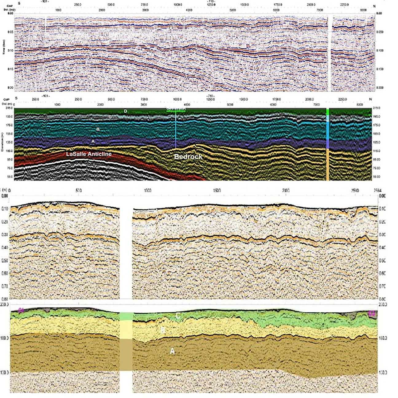
The principles of seismic P-wave reflection for the near surface involve using primary waves (P-waves) to study shallow subsurface geological formations. This method involves generating P-waves artificially, which then travel through the subsurface and reflect off interfaces between different geological materials. The travel times and amplitudes of these reflected waves can be analyzed to determine the depth, thickness, and composition of the subsurface layers. This technique is widely used in applications such as civil engineering, hydrogeology, and archaeology, where understanding near-surface geology is essential. The principles of seismic S-wave reflection method uses artificially generated S-waves, which are slower than primary waves (P-waves) and can only propagate through solid media. This method is particularly effective for detecting variations in shear strength, which can be vital for construction projects, landslide prediction, and studying shallow geological phenomena. As S-waves are less affected by water saturation than P-waves, their use in near-surface applications often provides more accurate subsurface images, especially in wet or fluid-saturated environments.
Seismic Refraction

The seismic refraction method is a geophysical technique used for investigating subsurface geological structures and layers. It is based on the principle that seismic waves change speed when they pass through different types of materials or layers in the Earth’s subsurface. This speed change often leads to refraction, or a bending of the seismic wave’s path. By measuring the travel times of seismic waves from a source to various detectors or geophones, it’s possible to calculate the velocities of the waves in different layers. This allows us to map the subsurface structures based on variations in seismic velocity. The method is particularly effective for delineating geologic layers and identifying features such as the depth to bedrock or the water table.
Downhole Seismic
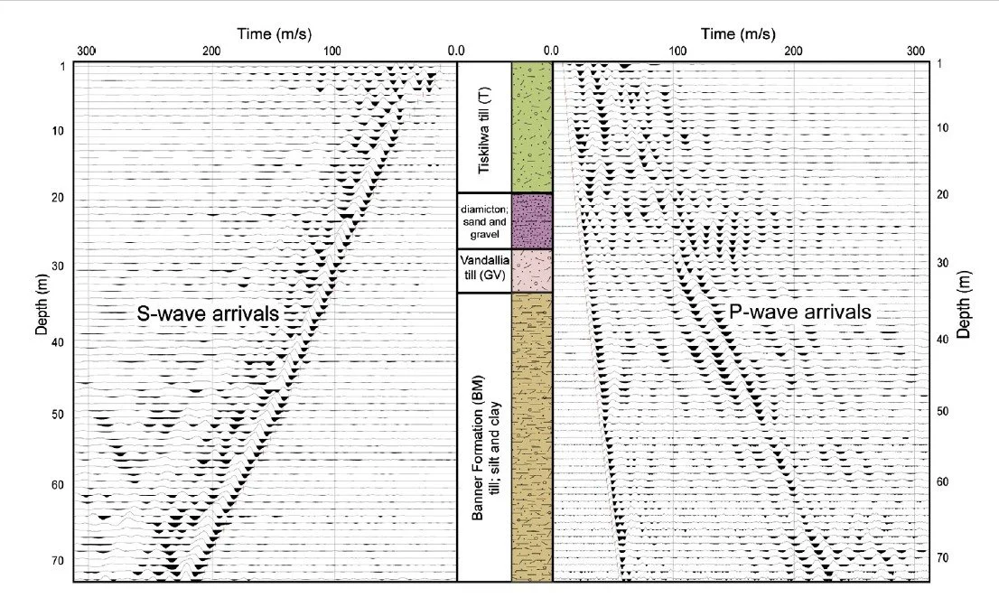
Downhole seismic surveys for the near surface involve the use of seismic waves, primarily P-waves and S-waves, to characterize the subsurface geological formations from within a borehole. In this method, a seismic source is placed on the ground surface or in a shallow borehole, while the receivers (geophones or accelerometers) are deployed in the same or another borehole. The source generates seismic waves that travel downward through the subsurface and are recorded by the downhole receivers. By measuring the time it takes for these waves to travel from the source to the receivers, the seismic velocity of the intervening geological layers can be determined. This method is often used to measure the velocity of P-waves and S-waves in the near surface, providing valuable information about the mechanical properties of the rock or soil, such as stiffness and strength. These measurements can be used in a variety of applications including site characterization for construction, assessing the stability of slopes, earthquake site response analysis, and locating subsurface geological features.
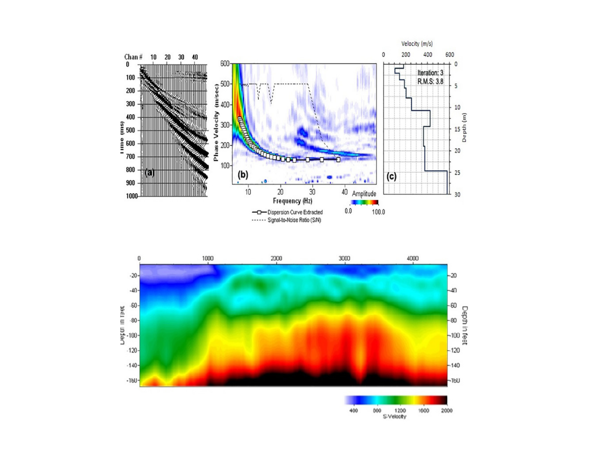
Multichannel Analysis of Surface Waves (MASW) & ReMi
Multichannel Analysis of Surface Waves (MASW) and Refraction Microtremor (ReMi) are non-invasive geophysical methods widely used to evaluate near-surface shear-wave velocity profiles. Both techniques analyze surface (Rayleigh) waves to characterize subsurface stiffness and elastic properties critical for geotechnical and seismic assessments. MASW relies on actively generated seismic energy recorded by an array of geophones, while ReMi utilizes naturally occurring ambient seismic noise as its energy source. In both methods, recorded waveforms are processed to generate dispersion curves, which are then inverted to derive shear-wave velocity profiles. These profiles provide essential information for assessing site conditions, seismic site classification, and ground response characteristics. ReMi is particularly effective for estimating Vs30, a key parameter in seismic hazard analysis, especially in urban or sensitive environments. Together, MASW and ReMi offer complementary, efficient, and reliable solutions for subsurface characterization in engineering, environmental, and infrastructure projects.
Electrical Resistivity & IP
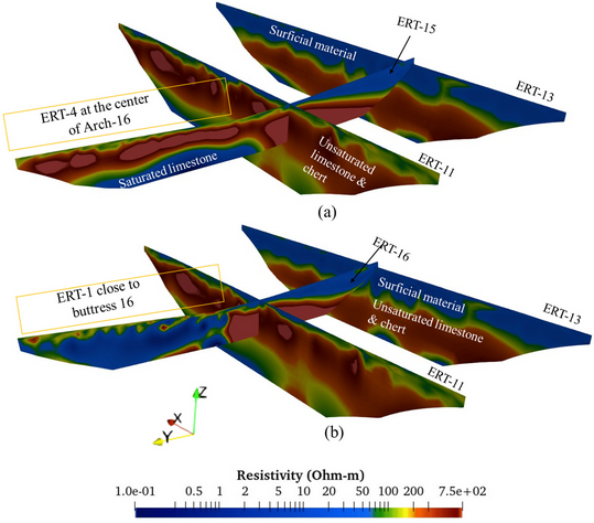
Electrical resistivity and induced polarization (IP) are geophysical methods used to probe the near-surface subsurface by investigating its electrical properties. In the electrical resistivity method, an electrical current is introduced into the ground through a pair of electrodes, and the resulting potential difference is measured through another pair of electrodes. The degree to which the subsurface resists the flow of this current is known as its resistivity, which varies with the type and condition of the material, including its porosity, saturation, salinity, and temperature. In the induced polarization method, a primary electric current is applied, and after it is switched off, the decay of the voltage is measured. This response provides information about the subsurface’s ability to polarize under an applied electric field, which is influenced by factors such as mineral content, grain size, and the presence of fluids. These methods are particularly useful in applications like groundwater exploration, mineral prospecting, and environmental surveys, providing a non-invasive means to identify and map variations in subsurface properties.
Self-Potential (SP)
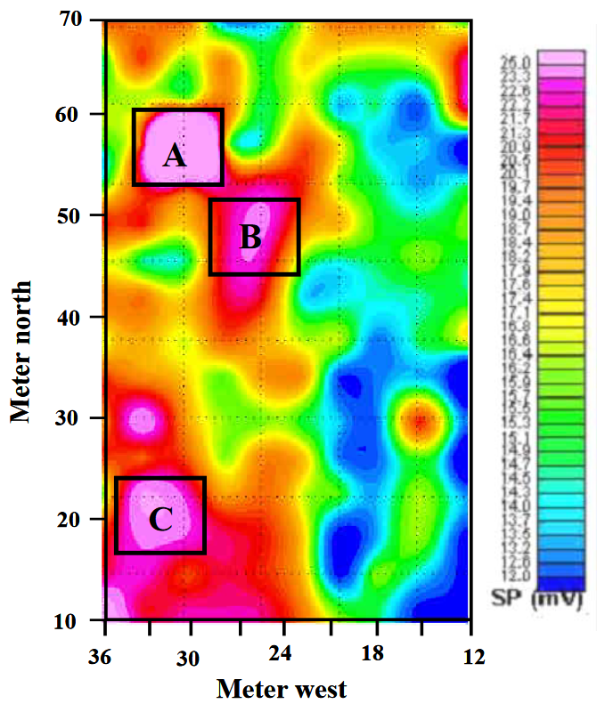
The Self-Potential (SP) method, also known as spontaneous potential, is a passive geophysical technique used to measure the natural electric potential differences in the Earth’s subsurface, without the need for an artificial electrical source. These potential differences are primarily generated by electrochemical reactions between different types of soil and rock materials, the flow of groundwater, and variations in temperature or concentration of certain ions. In an SP survey, electrodes are placed on the ground surface to record the variations in the natural electric field. By mapping these potential differences, we can infer the distribution of subsurface properties that influence the electric potential, such as the presence of water, mineral deposits, or hydrocarbon accumulations. The SP method has a wide range of applications, including exploration for mineral and water seepage from dams and leeves, hydrogeological investigations, and geothermal energy exploration.
Electromagnetic (EM)
Electromagnetic (EM) surveys are a type of geophysical method used to investigate the electrical conductivity of the near-surface subsurface. This is accomplished by generating an electromagnetic field using a transmitter coil and measuring the resultant secondary electromagnetic field using a receiver coil. When the primary electromagnetic field interacts with the subsurface, it induces electric currents known as eddy currents, which generate the secondary electromagnetic field. The strength and phase of this secondary field are related to the electrical conductivity of the subsurface. Different materials, including rocks, minerals, water, and contaminants, have different conductivities, and so they generate different secondary electromagnetic responses. By measuring these responses, EM surveys can identify and map variations in subsurface conductivity. This technique is commonly used in mineral exploration, groundwater surveys, and environmental studies.
Ground Penetrating Radar (GPR)
Ground Penetrating Radar (GPR) is a non-invasive geophysical technique used to image the subsurface of the Earth. The method involves transmitting high-frequency radio waves into the ground and recording the reflected signals. When the radar wave encounters a boundary between materials with different electrical properties, a portion of the energy is reflected back to the surface, while the rest continues deeper. The reflected signals are recorded by a receiver, and the travel times of these signals are used to determine the depth of the reflecting boundaries. The strength of the reflection is dependent on the contrast in electrical properties between different materials, allowing GPR to detect changes in material composition and the presence of objects or structures in the subsurface. GPR is widely used in a variety of fields, such as geology, archaeology, environmental studies, and civil engineering, providing a rapid and detailed image of the near-surface subsurface.
Magnetic Surveying
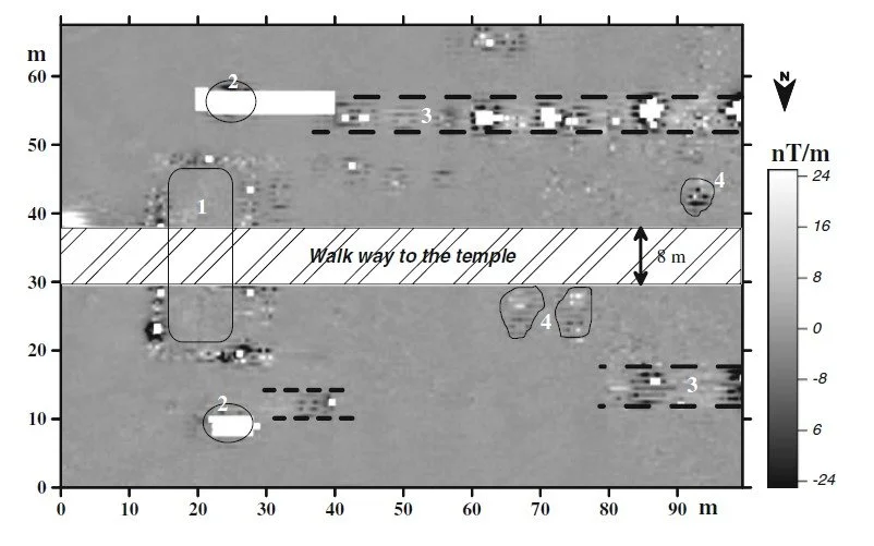
Magnetic surveying is a geophysical method used to measure variations in the Earth’s magnetic field caused by the presence of magnetic minerals in the subsurface. The basic principle involves the detection of anomalies, or differences, in the Earth’s magnetic field that are caused by variations in the magnetization of the subsurface rocks. These anomalies can be measured using a magnetometer, an instrument sensitive to magnetic fields. Depending on the type and concentration of magnetic minerals present, different rocks will produce different magnetic fields. By mapping these magnetic anomalies, we can infer the distribution of magnetic minerals in the subsurface and thus detect geological structures or features. Magnetic surveys are used in various applications including mineral and hydrocarbon exploration, archaeology, and unexploded ordnance detection, providing a non-invasive way to probe the near-surface subsurface.
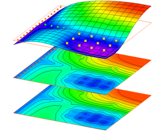
Gravity
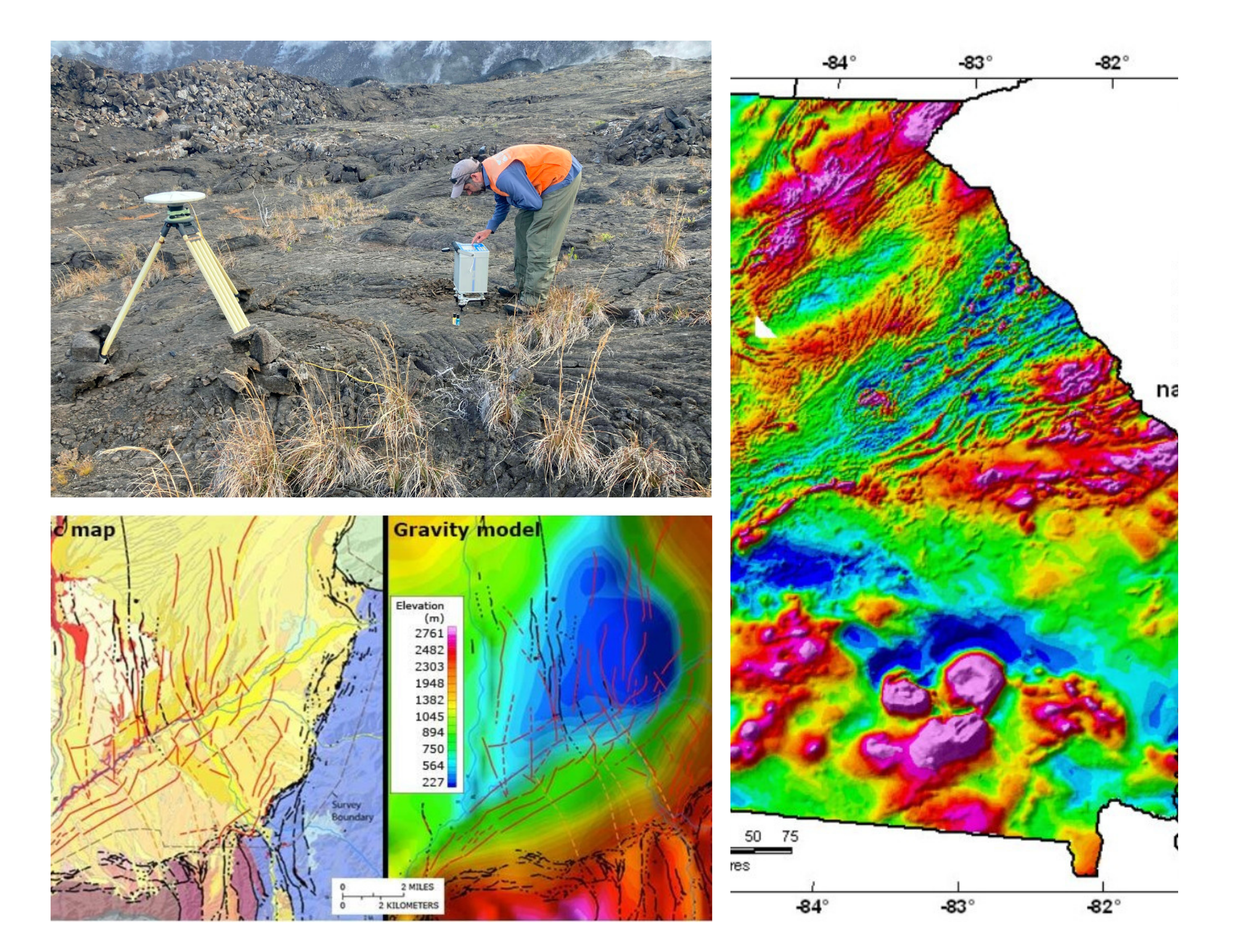
The gravity method in geophysics measures subtle variations in the Earth’s gravitational field that result from changes in subsurface rock density. It is commonly applied in geological investigations to map bedrock relief, sediment thickness, and major structural features such as faults and folds. In sinkhole and geohazard studies, gravity surveys are highly effective for identifying low-density anomalies associated with voids, cavities, and zones of subsurface collapse. In mineral exploration, gravity data are used to detect and delineate high-density ore bodies, including iron formations and massive sulfide deposits. Gravity surveys also support regional exploration by highlighting large-scale density contrasts related to intrusive bodies and basin architecture. Overall, the gravity method provides reliable subsurface insight while minimizing environmental and operational impact.
Numerical Modeling
Hydrological and hydraulic analyses form the engineering basis for evaluating surface water behavior, runoff, and flood conveyance across urban, rural, and arid catchments, including Wadi systems. Hydrological analysis addresses rainfall–runoff processes, catchment response, water balance, and climate impacts, while hydraulic analysis evaluates flow routing and capacity in channels, culverts, and drainage networks. Together, these analyses support flood protection design, hydraulic structures, numerical modeling, and authority submissions, ensuring reliable and technically sound water management solutions.
Pumping Test
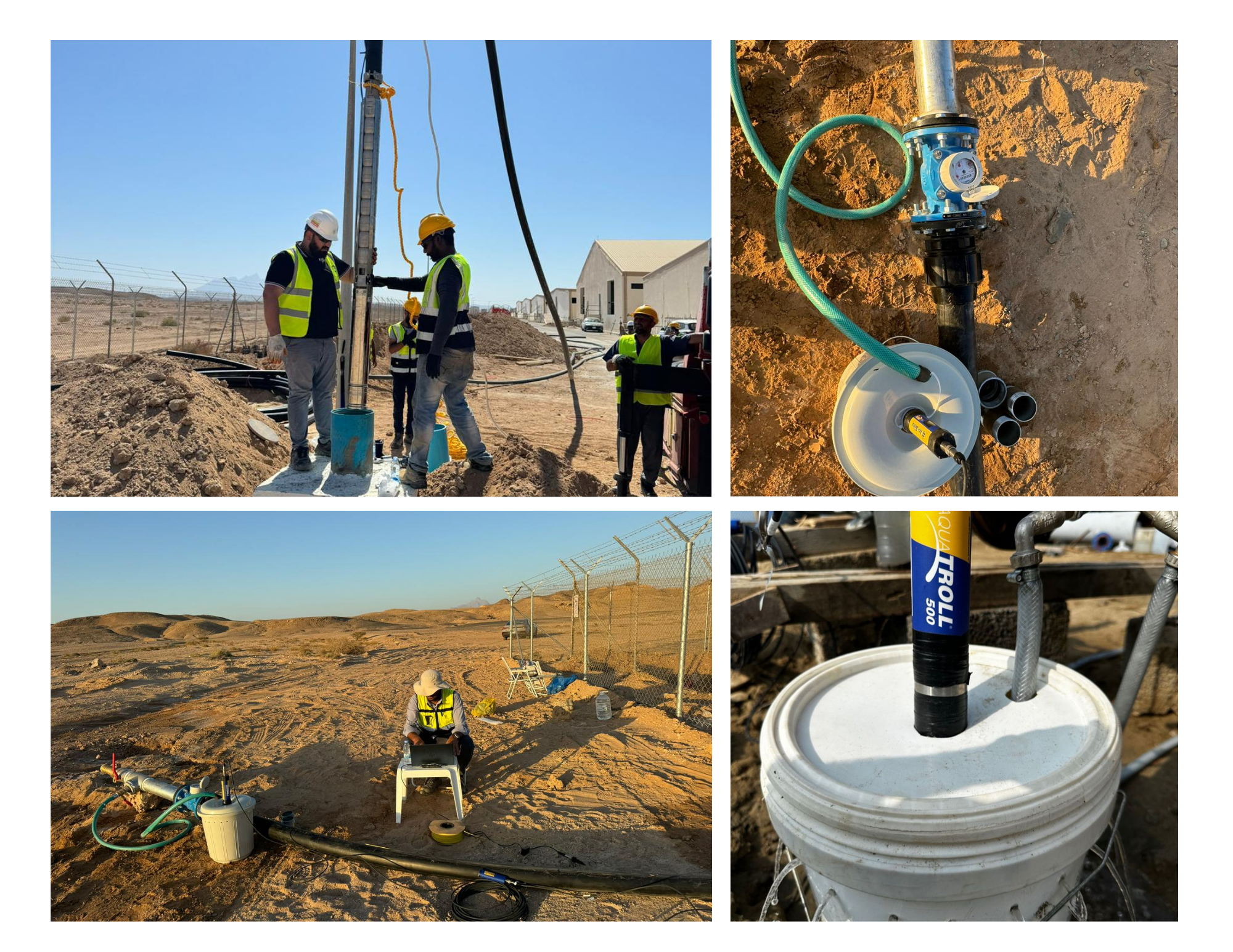
Pumping tests are a fundamental method for evaluating aquifer properties and supporting effective water management decisions. By pumping groundwater from a well at a controlled rate and observing water-level responses, key hydraulic parameters such as transmissivity, hydraulic conductivity, and storativity can be determined. Pumping tests provide direct insight into aquifer capacity, connectivity, and boundary conditions. They are widely used to assess well performance, sustainable pumping rates, and potential impacts on nearby wells or surface water bodies. The results support the design of water supply systems, dewatering projects, and groundwater management plans. Overall, pumping tests provide reliable field-based data essential for sustainable aquifer development and long-term groundwater management.
Slug Test
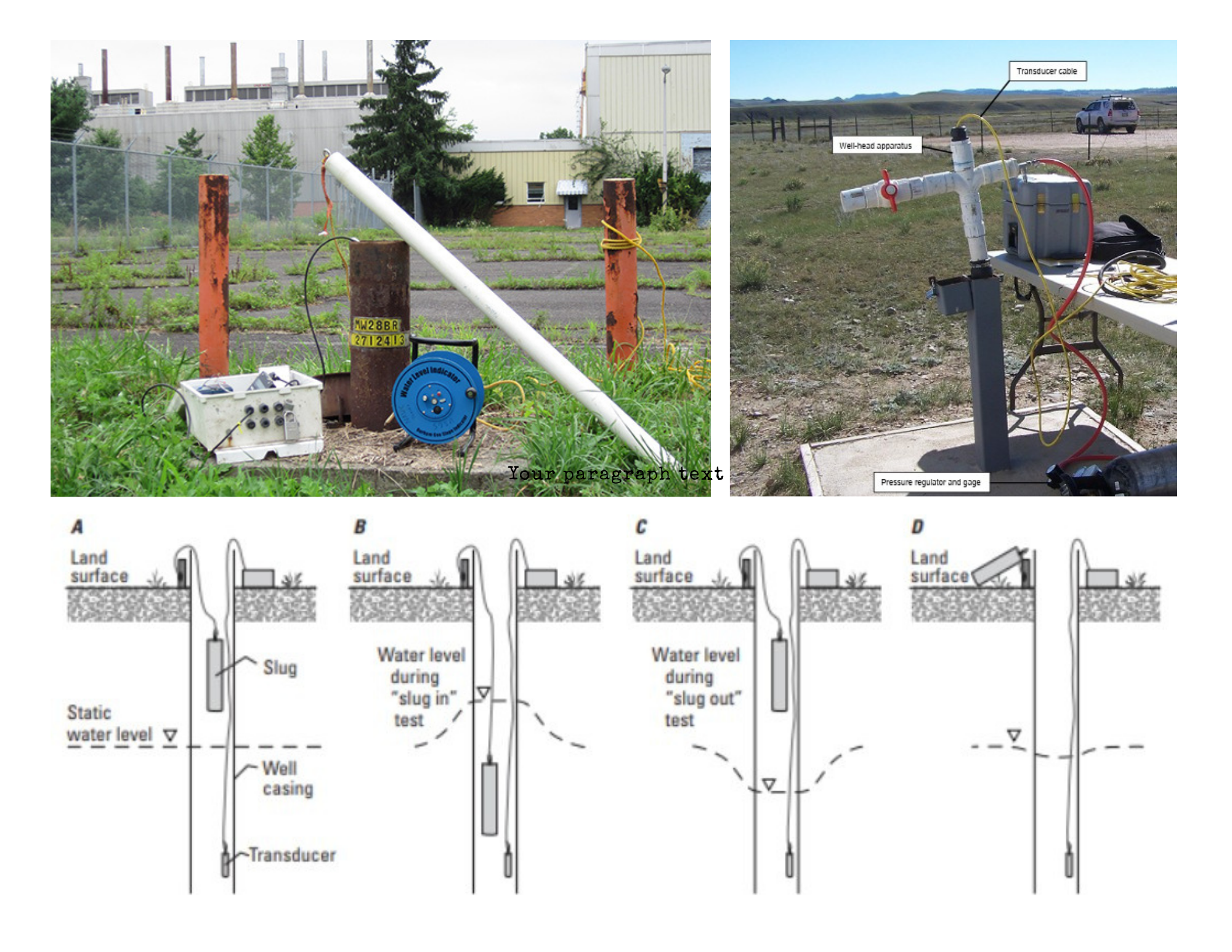
Slug tests are a widely used field method for evaluating aquifer hydraulic properties, particularly in low-yield or monitoring wells. The method involves introducing a sudden change in water level within a well and recording the aquifer’s recovery response over time. Slug tests are used to estimate hydraulic conductivity and assess local aquifer permeability. They are cost-effective, quick to perform, and require minimal pumping equipment. Slug tests are especially useful where pumping tests are impractical or where only small volumes of water can be extracted. The results support groundwater characterization, contaminant studies, and informed water management decisions.